Roads are vital infrastructure that facilitate transportation and connectivity. The history of human civilization is intertwined with road construction. This article provides a detailed look at what constitutes a road, the different criteria used to classify road types, their diverse applications and how road infrastructure has evolved over time.
What is a Road?
A road is a route between two places that has been leveled and paved to allow travel by vehicle transport like cars, buses and trucks as well as pedestrians, cyclists and animals.
Roads are far more than just the paths that allow us to drive from point A to B. They constitute a complex infrastructure system that facilitates trade, connectivity, and economic development. The evolution of road transportation over millennia has shaped human civilization and progress.
This article provides a comprehensive look at what constitutes a road, their critical components, and the diverse criteria for classifying road types based on attributes like capacity, location, access control and surface materials. Different road categories fulfill distinct transportation purposes, from high-speed travel on freeways to local access roads catering to neighborhoods. Urban and rural settings also necessitate different kinds of road infrastructure tailored to their usage and connectivity needs.
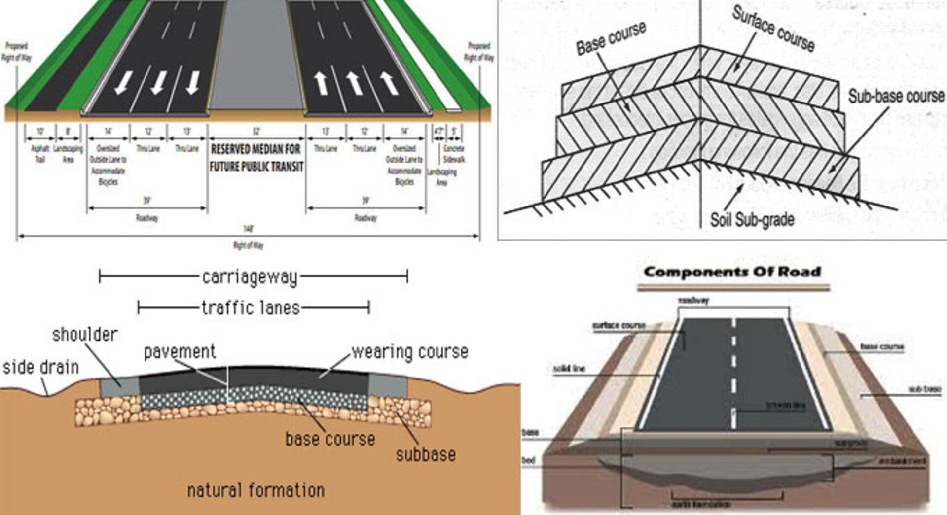
The primary components of a road are:
- Traveled way – The lane used by vehicles which may have one or more strips.
- Shoulders – The paved or unpaved strip adjacent to the traveled way.
- Verges – The lateral spaces between the road and private property lines.
- Right of way – The land including the road allotted for transportation purposes.
- Roadbed – The specially prepared earth surface on which road construction layers are built.
- Sub-base – The compacted soil layer over the roadbed that provides foundational support.
- Base course – The layer above sub-base usually made of crushed stone that distributes loads.
- Surface course – The top layer visible to users, made from materials like asphalt or concrete.
Classification of Roads
Roads can be classified based on multiple aspects like ownership, capacity, traffic allowed, location and surface type:
Based on Ownership
Public Roads owned by government transport agencies like highways, freeways etc.
Private Roads owned by private individuals or communities like roads in housing complexes.
Based on Vehicle Capacity
Single Lane Roads with only one lane for vehicular movement and passing.
Two Lane Roads allowing two lanes of traffic, one in each direction.
Four Lane Roads having two lanes on each side for higher volume traffic flow.
Six Lane Roads designed for very high volumes of traffic with 3 lanes on each side.
Based on Traffic Allowed
Arterial Roads meant for high speed through traffic not requiring access to properties.
Collector Roads collecting and distributing traffic between arterials and local roads.
Local Roads with access to residential streets and individual properties.
Limited Access Roads like highways with access only from designated points.
Based on Location
Based on Location and Function
- National highways- National highways are the main roads that connect all major cities to the capital of the country. They run throughout the length and breadth of the country. A minimum two-lane road is provided for national highways.
- State highways- State highways are the second main roads that connect significant parts of the state within it. State highway ultimately connects to the national highways.
- District roads -District roads are provided within the cities and connect markets and production places to state and national highways. Two types of district roads are there namely, Major district roads and Minor district roads. Major district roads connect headquarters of the neighboring district with main parts of the area while minor district roads are laid within the region.
- Rural roads or village road – Village roads connect the nearby villages. They lead to a nearby town or district roads. Usually, low-quality roads are provided as village roads because of low traffic.

Based on Surface Type
Asphalt/Bitumen Roads using asphalt as the binding surface material.
Concrete Roads paved using concrete material for superior durability.
Gravel Roads with gravel mixed with dirt as the surface layer.
Dirt Roads with only the natural soil as the surface, prone to dust and reduced passage when wet.
Different Types of Roads and their Purposes
Roads serve different transportation purposes based on their capacity, location, access control and high speed capability:
Highways
Major roads that span long distances to connect cities and towns. Allow high speed traffic movement with limited access control via on/off ramps.
Arterial Roads
Major urban roads with higher lane capacity meant for smooth cross-city traffic flow. Avoid congestion from property access.
Collector Roads
Roads collecting traffic from local streets in residential areas and feeding it to arterial roads. Allows local access.
Local Roads
Roads in neighborhoods and communities providing direct access to individual properties and homes.
Streets
Public roads in areas with buildings on both sides. Provide local area access and parking.
Alleys
Narrow lanes between buildings giving access to parking and service areas. Too narrow for through traffic.
Freeways
Major limited access highways for high speed inter-city travel. Entry/exit permitted only at grade separated interchanges.
Historic Evolution of Road Infrastructure
Road construction has evolved over centuries from dirt tracks to sturdy engineered networks:
Early Roads
The first roads were dirt tracks made by repeated use for walking and later chariots. No paving was done. Maintenance was poor.
Stone Paved Roads
Roman roads 2000 years back were the first stone paved roads. These provided a hard, durable surface and better drainage.
Gravel Roads
Gravel mixed with dirt became a cheaper and better alternative to pave roads than stone blocks. Easier to repair than stone surfaces.
Macadam Roads
Macadamization introduced aggregate sub-base under the gravel surface for better load distribution in early 19th century.
Asphalt Roads
20th century saw increasing use of asphalt as road binder for improving water resistance and a smoother surface.
Concrete Roads
Concrete provides the most durable and maintenance-free road surface. Advances like reinforcement bar and jointing improved concrete road quality.
Electronic Toll Roads
21st century roads use electronic toll collection, traffic coordination and safety systems for efficient route usage.
Classification of Roads Based on Capacity and Traffic
Roads are designed to handle different volumes of traffic based on their location, purpose and usage intensity:
Here is a classification of roads based on traffic volume:
Expressways
Designed for highest volumes of fast-moving traffic. Typically have controlled access and grade separation. Traffic volumes exceed 30,000 vehicles per day. Major 6 or 8 lane highways meant for high speed inter-city travel capable of carrying very high traffic volumes.
Arterial Roads
Major roads handling large traffic volumes across urban areas. Volumes range from 15,000 to 30,000 vehicles per day. Enable efficient cross-city traffic flow. Important 4 lane roads connecting smaller towns and large villages. Cater to moderate to high traffic volumes.
Collector Roads
Interconnect smaller roads and provide links to arterial roads. Cater to moderate traffic volumes of 5,000 to 15,000 vehicles per day.
Local Roads
Roads in residential areas meant for access to individual properties. Very low traffic volumes up to 5,000 vehicles per day.
Rural Roads
Two lane roads spanning medium distances between smaller rural centers. For light to moderate traffic. Roads connecting villages and hamlets in rural areas. Traffic volumes less than 2,000 vehicles per day.
Service Lanes
Separate lanes adjacent to arterial roads meant for slow local traffic. Main rural area roads connecting villages. Single lane with occasional passing places for low traffic volumes. Very low volumes catering only to adjoining properties.
So in summary, higher category roads like expressways and arterials carry higher volumes of traffic at greater speeds, while collector, local and rural roads have progressively lower traffic meant only for property access and local movement.
Class V Roads
Roads giving access within residential areas and properties in villages and urban centers. Very light traffic.
Class VI Roads
Local rural roads used mainly by agricultural traffic. Very low traffic, not suitable for fast movement.
Types of Roads for Urban and Rural Areas
Road needs in urban and rural settings differ based on usage patterns, connectivity needs and construction challenges:
Urban Roads
- Arterial roads for fast within-city travel
- Collector roads gathering traffic from local streets
- Local streets with parking for access to residences
- Flyovers and underpasses to avoid intersections
- Paved footpaths, cycling tracks and public transit lanes
- High capacity road network spanning the entire area
- Reinforced concrete surfaces for heavy, stop-go traffic
- Integrated traffic control and safety systems
Rural Roads
- Connecting villages to towns and highway network
- Gravel or brick surfaces due to lower traffic
- Single lane with occasional paved passing places
- Bridges instead of culverts for stream crossings
- Dirt trails providing farm access
- Sparse road network covering large distances
- Lower capacity based on small village size
- Focus on low construction and maintenance cost
Major Highway and Freeway Types in the US
The US has an advanced system of controlled access highways and freeways for rapid long-distance travel:
Interstate Highways
The Dwight D. Eisenhower National System of Interstate and Defense Highways, commonly called the Interstate Highway System, is the highest road classification in the US spanning 77,017 km. It allows high-speed travel between states without intersections.
U.S. Routes
Important arterial roads under the jurisdiction of state and local agencies. Numbered below 100 based on location. Constructed and maintained by state governments using federal grants.
State Highways
Designated and numbered by state governments according to their standards. Provide connectivity between counties and important local centers within each state.
County Highways
Roads maintained by county governments linking towns and villages in rural areas and supplementing state highways.
Farm-to-Market Roads
Important road systems in many states connecting agricultural areas and farms with market towns. Carry both local and through traffic.
Common Road Surface Materials and Comparisons
Road surface quality and durability depends on the materials used:
Asphalt
Made by mixing bitumen with aggregates. Provides a smooth ride and low noise. Prone to rutting and needs periodic resurfacing. Average cost.
Concrete
Very durable and pothole resistant surface. Rigid slabs can crack and be noisy. High construction cost but low maintenance.
Gravel
Inexpensive surface material that is easy to repair. Dusty and unsuitable for heavy traffic. Improves dirt road usability when wet.
Brick
Durable, aesthetic and permeable surface. No resurfacing needed and very long lasting. High material and construction cost.
Cobblestone
Quarried stone blocks give an attractive appearance. Extensive manual labor needed for laying. Costly but requires negligible maintenance.
How to Identify Types of Roads on a Map
Determining road types is easiest using a detailed map identifying key attributes:
- Number of lanes – Higher lane numbers indicate arterial roads and highways.
- Surface color – Concrete or brick surfaces marked differently than asphalt or gravel.
- Border signs – Names of places connected to suggest higher order arterial roads.
- Intersection treatment – Grade separated interchanges imply controlled access freeways.
- Location markers – Mile markers, exit numbers and route designations denote major highways.
- Utility lines – Presence alongside roads implies access to residences. Missing on highways.
- Police/fire symbols – Important arterials marked differently from neighborhood streets.
- Parking indication – Parallel or angled parking implies slower local streets.
- Road width – Wider lines used for higher capacity roads and highways.
- Bridges/tunnels – Used for major roads crossing rivers/hills while minor roads divert.
Advantages and Disadvantages of Concrete vs Asphalt Roads
Concrete and asphalt are the most common paving materials, each with pros and cons:
Concrete Roads
Advantages:
- Very long life span without much maintenance
- Not affected by fuel spills or weed growth
- Bright surface improves night time visibility
- Less prone to rutting from heavy vehicles
- Does not degrade due to weathering
Disadvantages:
- Higher initial construction cost
- Cracking from ground movement
- Noisy surface due to vibration
- Minimal flexibility leading to uneven surfaces over time
Asphalt Roads
Advantages:
- Smoother surface provides greater skid resistance
- Lower construction cost than concrete
- Easy to repair by re-asphalting damaged sections
- Flexibility prevents cracking due to ground settlement
- Quiet surface for reduced tire noise
Disadvantages:
- Shorter lifespan requiring resurfacing every 10-15 years
- Vulnerable to damage from fuel and oil spills
- Rutting occurs more easily under heavy traffic
- Poor weather resistance leads to potholes in rain or snow
Best Practices for Naming and Numbering Road Types
Systematic naming and numbering conventions for different road types makes navigation easier:
- Freeways identified by direction like I-40 East or highway route number – I-95
- Arterial roads in cities named after the city – Boston Road
- Numbered street naming system in city blocks – 7th Street, 8th Street
- One street name through entire length without changes
- Odd and even street numbers on opposite sides
- Consecutive house numbers allotted from city center outwards
- Higher number highways get odd numbers, lower level roads assigned even numbers
- Mile markers every 1/10th or 1/2 mile intervals on highways
- Exits numbered as per corresponding mile marker – Exit 34 is at mile marker 34
- Use of standardized suffixes like St, Rd, Blvd based on road type
- Clear signage before intersections indicating names of crossing roads
Role of Road Types in City and Transport Planning
Urban planners use road classification to develop integrated transport facilities:
- Arterial roads for fast travel without access to properties
- Collector roads gather traffic from access roads leading to arterials
- Local streets used only for property access prohibit through traffic
- Segregating pedestrian, cycling and vehicular traffic
- Service lanes for parking and commercial access without hampering through lanes
- Appropriate road capacity provision based on projected population density
- Connecting roads to form hierarchy of high speed travel between zones
- Identifying routes between major hubs like industrial areas, hospitals, schools etc.
- Preserving existing natural features by planned road layouts
- Greenery and landscaping along wide roads and medians
- Controlling development by granting access from lower order roads
Construction of Roads
Modern road construction involves systematically building up successive layers on prepared sub-grade:
- Removal of topsoil to expose firm strata beneath
- Compacting sub-grade by rolling and sprinkling water
- Spreading sub-base coarse aggregate layer
- Compacting sub-base using rollers to provide load bearing strength
- Laying stone aggregate base course layer
- Compacting base course and checking for design thickness
- Applying bitumen primer coat on base for waterproofing
- Spreading bitumen bound macadam layers to required camber
- Rolling finished surface to attain desired density and grade
- Seal coating for weather protection of macadam and for frictional resistance

The crown provided ensures rainwater runs off the center. Quality controls include testing of fill material, layer thicknesses, compaction and surface finish.
Types of Road Network Patterns
Some commonly used patterns when planning road networks for an area are:
Grid Iron Pattern
Roads intersect each other at right angles to form rectangular blocks. Easy navigation but increased intersections. Common in places with flat geography.
Radial Pattern
All roads spread out like spokes from a central point. Mainly used for historical towns centered on a focal point like a fort, palace or cathedral.

Linear Pattern
Roads are laid approximately parallel like in a grid but following existing terrain instead of right angles. Used in hilly areas.
Ring and Radial Pattern
Radial roads from a center point integrate with circular ring roads around the center. Combines access with traffic distribution.
Hybrid Networks
Combination of linear, radial and grid patterns used in tandem. Grid predominates in core city areas while radial roads provide wider suburban connectivity.
The topography, population density and layout of existing settlements determine the optimal pattern for road network connectivity in an area.
conclusion
Advancements continue to enhance road quality and capabilities. Modern construction standards and materials like asphalt and concrete have increased road durability and longevity. Smart electronic systems now allow real-time coordination of traffic flows for optimal utilization of road capacity and enhanced safety.
As road infrastructure forms the circulatory system for mobility and goods transport, understanding the tailored purpose of each type of road is essential knowledge for civil engineers and urban planners focused on developing sustainable, efficient transportation networks.


