In the world of science and technology, the concept of elevation in civil engineering plays a crucial role in shaping our understanding of structures and landscapes.
Elevation refers to the vertical distance of a point or object relative to a reference datum, such as sea level or a specific benchmark.
Building elevations, or exterior facade drawings, are a critical part of architectural and civil engineering design.
Civil engineers rely on accurate elevation data to design and construct various projects, including buildings, bridges, roads, and water systems.
Elevations are typically represented through detailed drawings or digital models, which provide a comprehensive view of the structure’s vertical dimensions and its relationship to the surrounding terrain.

By carefully analyzing and manipulating elevations, civil engineers can ensure that their designs are safe, functional, and harmoniously integrated with the natural environment. Understanding elevation is essential for effective site planning, drainage management, and the overall success of civil engineering projects.
This in-depth guide covers everything related to building elevations – what they are, why they matter, elevation standards, materials, and best practices for residential and commercial buildings.
What is a Building Elevation in Civil Engineering?
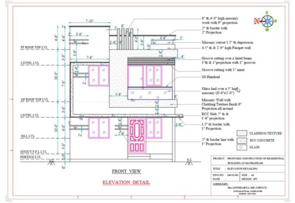
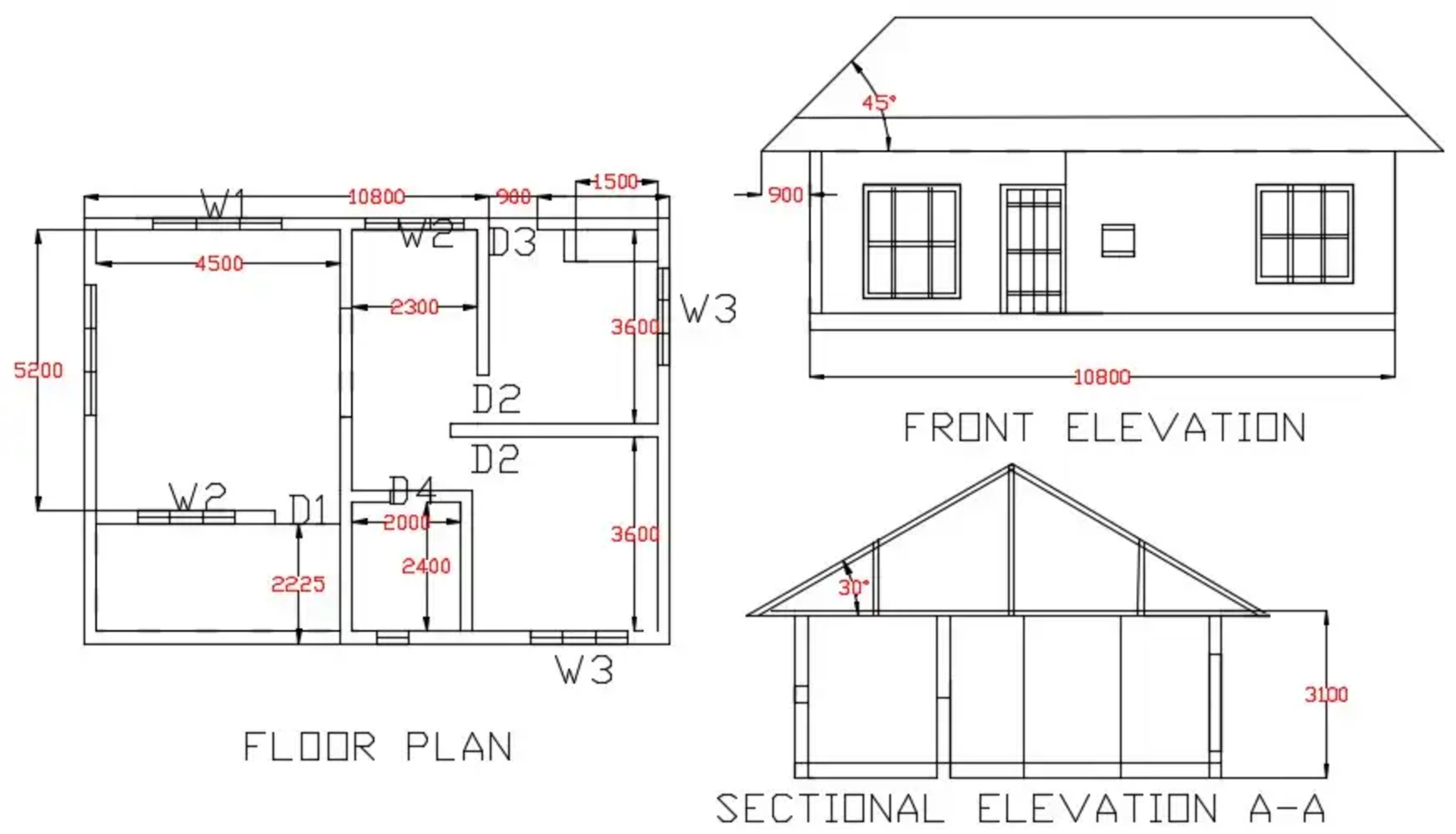
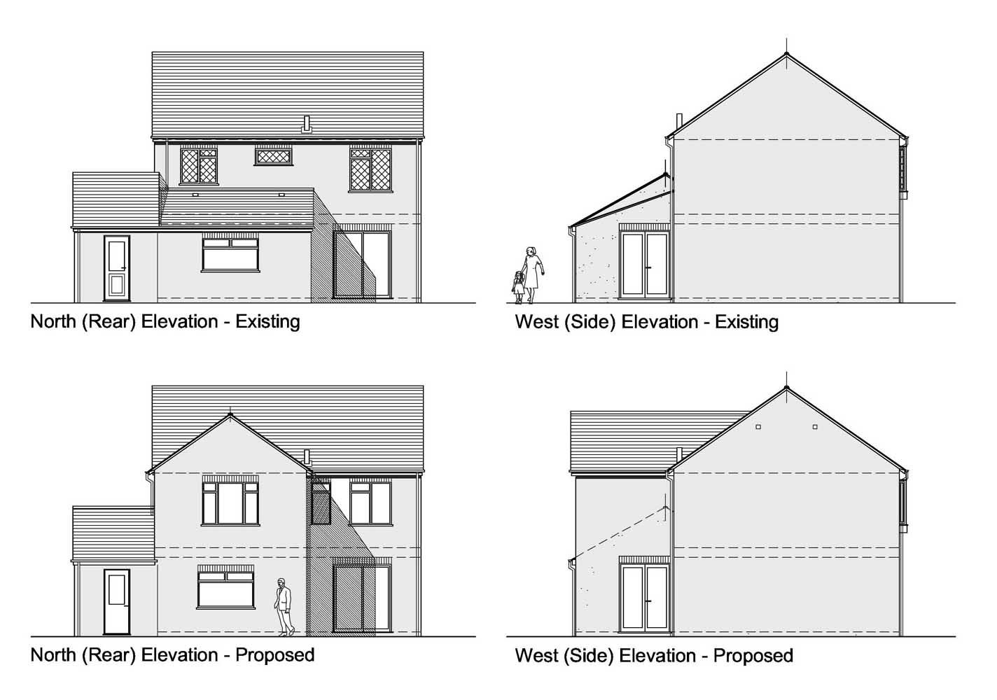
A building elevation is an architectural drawing depicting the exterior facade of a structure. Elevations are orthographic projections showing the height, width, depth, and design features on a building’s exterior.
Elevations provide important information for construction including:
- External materials, finishes, and architectural details
- The location and size of doors, windows, and openings
- Vertical dimensions and heights
- Exterior structural and decorative elements
- Visualization of the aesthetics and styling
Elevations are drawn to scale like floor plans and sections. But unlike plans or sections, elevations show the true exterior appearance without cutting through the building.
Why are Building Elevations Important?
There are several key reasons elevations are critical for civil engineering and construction:
Visualization
Elevations help visualize and communicate the exterior design, aesthetics, scale, and proportions. They show how the building will look in real life better than plans or 3D models. This allows stakeholders to provide feedback on the exterior.
Complements Plans & Sections
Plans and sections detail interior spaces but lack exterior façade information. Elevations complement these drawings by providing exterior dimensions, openings, materials, and components.

Construction Accuracy
With detailed material types, locations of doors/windows, exterior finishes, and vertical dimensions, elevations ensure the exterior shell can be built accurately.
Code and Zoning Compliance
Local zoning, planning, and building codes often regulate facade aesthetics and elements like window-to-wall ratio. Elevations ensure compliance.
Cost Estimating
Accurately estimating exterior material quantities and construction costs requires the details provided in elevation drawings.
Documentation and Records
Elevations serve as permanent records of the exterior design for facilities management and future renovations or additions.

Types of Building Elevations
There are several common types of building elevations:
Front Elevation
The front elevation faces the primary street or entrance side of the building. This facade receives special design focus and contains the main architectural features and entry.
Rear Elevation
The rear elevation is on the backside of the building. Service entries, utilitarian materials, and minimal openings are common.
Side Elevations
The two side elevations run perpendicular the front and rear. These often have fewer openings and less detail than the front.
Corner Elevations
For buildings on corner lots, the corner elevations treat the sides exposed to the intersecting streets as enhanced facades.
Interior Courtyard Elevations
Elevations facing interior courtyards are also developed to have architectural detail, akin to front facades.
All Sides Elevation
A single elevation can also depict all sides of the building in one drawing. This is more common for smaller buildings.
Best Practices for Building Elevations
Several best practices help produce quality building elevations:
Drawn to Scale
Elevations should be drawn to the same scale and datum as the plans, sections, and other drawings. This ensures consistency across documents.
Include Dimensions
Important dimensions such as building heights, window/door sizes, exterior material thicknesses, and vertical control points should be shown.
Material Notations
The drawings must clearly label all exterior materials and finishes for accurate communication and construction.
Design Consistency
Elevations should match plans, sections, 3D models, and other drawings to ensure a cohesive and buildable design.
Include Key Details
Key details like material interfaces and transitions, special facade elements, and exterior equipment need to be shown.
Follow Standards
Elevations should adhere to industry drafting standards, building codes, and jurisdiction requirements.

Recommended Scales for Building Elevations
The architectural scale used depends on building size and level of detail:
- Small residential: 1/8” = 1’-0”
- Large residential: 1/4” = 1’-0”
- Commercial low-rise: 1/8” = 1’-0”
- Commercial high-rise: 1/16” = 1’-0” or 1/32” = 1’-0”
Large scales show more detail. Smaller scales are needed for larger structures to fit on paper.
Key Elements to Include on Elevations
Quality elevation drawings will incorporate:
- Exterior doors, windows, openings shown accurately
- Vertical dimensions for heights, openings, and floor/ceiling alignments
- Horizontal dimensions for overhangs, offsets, and feature sizes
- Masonry coursing shown and dimensioned
- Exposed foundations, footings, grade beam sizes
- All exterior materials labeled clearly
- Exterior wall construction detailed
- Roof slopes, overhangs, drainage, and penetrations
- Decorative and functional elements like cornices, parapets, railings
- Mechanical/Electrical elements like louvers, vents, equipment
- Lighting fixtures and security devices
- Any special facade features or treatments
Common Architectural Elevation Materials
Typical exterior building materials specified on elevations include:
Masonry
- Brick
- Concrete masonry units
- Stone veneer
- Stucco
Metals
- Steel (panels, architectural shapes)
- Aluminum (panels, storefronts, railings)
- Stainless steel (panels, hardware)
Glass
- Vision glazing
- Spandrel glazing
- Operable windows
- Curtain wall systems
Wood
- Siding
- Decorative timbers
- Wood decking
Composites
- Fiber cement panels
- EIFS
- Metal composite panels
Roofing
- Asphalt shingles
- Standing seam metal
- Membrane roofing
Best Elevations for Residential Buildings
Some elevations are preferred for residential structures:
Front Elevation
The front facade plays a major role in home curb appeal. Asymmetric design with a focus on the main entry is recommended. Mixing siding with brick veneer adds interest.
Rear Elevation
Minimize windows on the rear to enhance privacy. Incorporate decking, sunrooms, and porch additions.
Side Elevations
Maintain similar finishes and roof lines as the front for consistent street views. Strategically add windows to balance natural light with privacy.
Southern Exposures
South facing elevations receive the most direct sun. Use overhangs and tinted glass to control heat gain.
3D Renderings
In addition to 2D elevations, developing exterior 3D renderings helps homeowners visualize the design.
Proper attention to residential elevations creates attractive elegant homes and maximizes property values.
Architectural Elevation Standards
Quality architectural elevations follow industry drafting standards for layout, dimensionality, labeling, notation, and completeness. Key standards include:
- Title blocks with project information
- Drawing orientation indicators (north arrow)
- Column grids, datum, and benchmark references
- Proper line weights and types
- Scale noted with graphic scale
- Dimensions in feet and inches
- Doors and windows labeled and scheduled
- All materials tagged with legends
- Drawing indexed if multiple sheets
- Revisions documented
Standardized professional elevations ensure clear communication for bidding and construction.
FAQ – Elevation in Civil Engineering
What is the importance of elevation in civil engineering?
Accurate elevation data is essential for designing and constructing structures, ensuring proper drainage, and managing the flow of water. Elevations also help in determining the amount of earthwork required, such as cutting and filling, to create a suitable foundation for the project. Additionally, elevations are used to ensure that structures are built to the correct height and align with the surrounding landscape and infrastructure.
How are elevations measured in civil engineering projects?
Civil engineers use various methods to measure elevations, depending on the project’s requirements and available technology. Some common methods include:
a. Surveying: Traditional surveying techniques, such as leveling and theodolite measurements, are used to determine elevations accurately.
b. Global Positioning System (GPS): GPS technology allows engineers to obtain precise elevation data using satellite-based positioning.
c. Light Detection and Ranging (LiDAR): LiDAR is a remote sensing method that uses laser pulses to create detailed 3D models of the terrain, including elevation information.
d. Drone Surveys: Unmanned aerial vehicles (UAVs) equipped with cameras and sensors can capture high-resolution aerial images and generate digital elevation models.
What is a benchmark in relation to elevation?
In civil engineering, a benchmark is a fixed reference point with a known elevation. Benchmarks serve as a starting point for measuring the elevations of other points within a project site. These reference points are typically established by government agencies or geodetic surveys and are marked with permanent monuments or markers. Civil engineers use benchmarks to ensure consistency and accuracy in their elevation measurements throughout the project’s lifecycle.
How do civil engineers represent elevations in drawings and plans?
Civil engineers use various methods to represent elevations in their drawings and plans, depending on the project’s requirements and the level of detail needed. Some common methods include:
a. Contour Lines: Contour lines are used to represent points of equal elevation on a topographic map. The spacing between contour lines indicates the steepness of the terrain.
b. Spot Elevations: Spot elevations are specific points on a drawing or plan with their respective elevation values noted. These points provide discrete elevation information at critical locations within the project site.
c. Elevation Profiles: Elevation profiles are cross-sectional views that show the vertical alignment of a structure or terrain along a specific path. These profiles help engineers visualize the changes in elevation and design accordingly.
d. Digital Elevation Models (DEMs): DEMs are digital representations of the terrain’s surface, where each pixel or grid cell contains an elevation value. DEMs are used in computer-aided design (CAD) software and geographic information systems (GIS) for various analysis and design tasks.
The Role of Elevations in Civil Engineering
Building elevations are vital for several civil engineering applications:
Structural Design
Elevations show critical structural information like wall openings, floor-to-floor heights, vertical supports, and foundation requirements architects and structural engineers require.
Construction Engineering
Construction managers rely on elevations for material takeoffs and cost estimation. They inform construction planning, equipment needs, and project timelines.
Site Development and Grading
Elevations provide building heights and perimeter information essential for proper site grading and drainage around structures.
Building Code Compliance
Codes govern aspects like allowable areas, fire ratings, facade materials, and egress. Elevations demonstrate compliance.
LEED and Sustainability
Sustainable design standards relate to building orientation, massing, and facade design. Elevations document these strategies.
Careful development of building elevations by civil engineers is crucial for delivering high-quality, long-lasting built projects.
Conclusion

Building elevations are a critical piece of the design puzzle, showing the exterior aesthetics and details that complete the architectural vision.
Carefully drafted elevations that follow best practices and industry standards ensure the facade can be accurately constructed as intended. Elevations complement other drawings to provide a holistic view of the exterior design.
As civil engineers work through schematic concepts to construction documentation, developing professional elevations should remain a high priority. Doing so results in world-class architecture and buildings that stand the test of time, blending engineering excellence with beautiful and functional design.


